The parking for Chimney Mountain and Puffer Mountain Cliff has been closed. No alternative has been investigated. According to this article, the owners are working with DEC on a solution, and hope "to open the parking area back to the public, possibly by spring."
Huckleberry Mountain has a complicated history of access. The approach to Huckleberry Mountain from Paintbed Road, described on pages 492–493 of the first printing of the first edition (2008), crosses two parcels of private land before entering state land. The approach is the same as that for the Paint Mine Ruins, and has long been described in various hiking and climbing guidebooks to the region. These owners posted their property and effectively ending climbing at Huckleberry Mountain.
Until recently, the only legal approach to Huckleberry Mountain involved going over Crane Mountain and buchshacking down the other side, a strenuous and time-consuming adventure. This is the approach described in the Second Edition (2014). Click here for an exerpt from the second edition describing this approach.
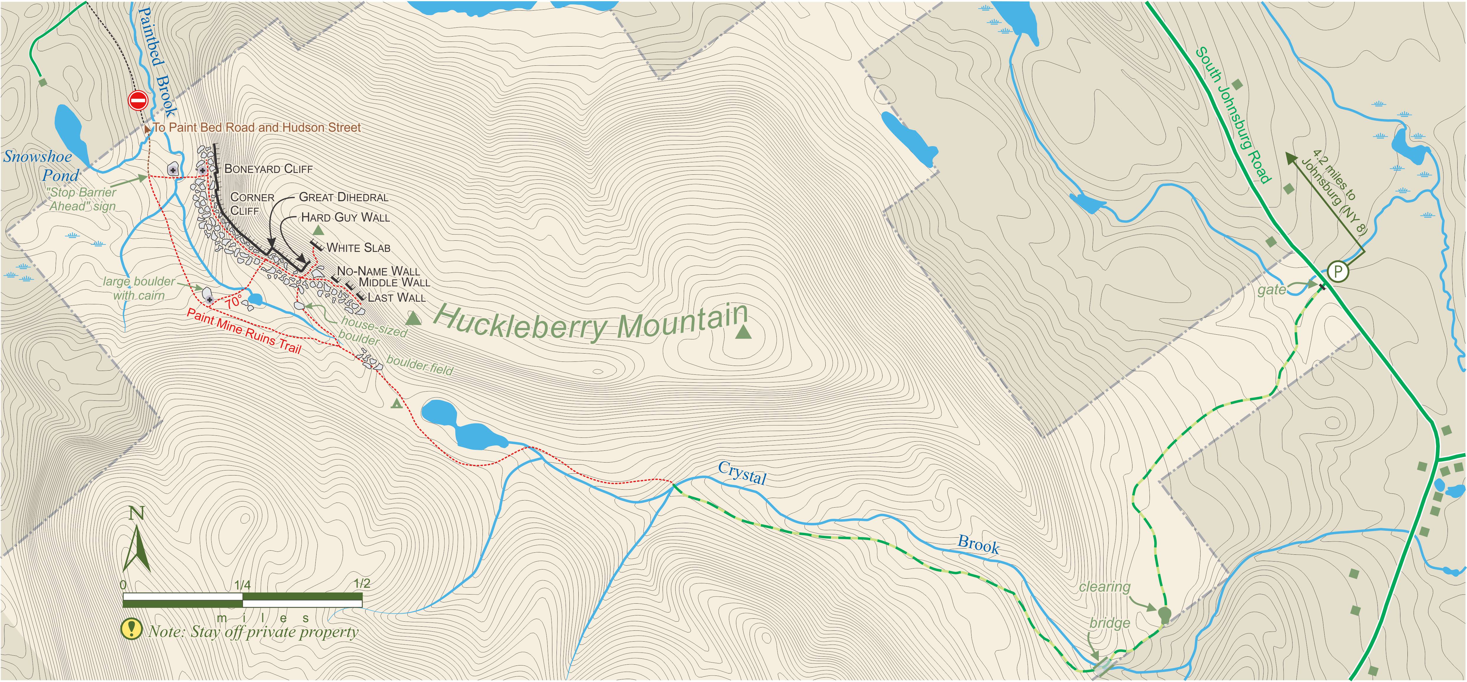
In December 2017, the Open Space Institute purchased land that promised an easier approach, and in May of 2021, this parcel was transferred to New York State. While the approach is still long, it gains and loses far less elevation.
Directions: From NY 8 in Johnsburg, drive south on the South Johnsburg Road for 4.2 miles. Park on the west shoulder of the road next to a gated dirt road 586457,4824328. This parking area is 0.4 mile north of the intersection of Glen Creek Road and South Johnsburg Road.
From the parking area (0 min), hike west along the dirt road and at 30 min cross a bridge over Crystal Brook. At 45 min the dirt road ends at a clearing next to Crystal Brook 584090,4823511. Cross the brook and continue west on an old logging road that follows the north side of the brook. At 1 hr reach the Forest Preserve boundary. Continue along the logging road to a pond (1 hr 15 min) near the height of land. Continue west on the logging road, past foundations and a ruined chimney, and descend past house-sized boulders to a swamp beneath the cliffs. Leave the logging road 582919,4824205 and bushwhack around the east side of the swamp and up to the Main Cliff, reached at 1 hr 45 min.
Click here for a map showing the new approach to Huckleberry Mountain.
This area is described in the second edition (2014), Volume 2, page 80.
As of July 2019, the private land you cross to reach Potash Cliff has active logging and the directions for accessing the cliff has changed (see below). Both the parking and trail are easy to find and make for a fast approach to Potash. That said, there are still several access issues to remember when visiting the cliff; respect private land access, obey Peregrine Falcon closures, and observe snowmobile right-of-way along Potash Road. The local snowmobile club has the right-of-way from December to April for the uphill (east) shoulder of Potash Road. Take this into consideration when parking and walking the road to the approach trail. The approach to Potash Cliff crosses private property, specifically, the new trail that goes directly uphill between the road and the cliff. The landowner generously allows climbers to access the state land using this trail. Avoid loitering at the parking area and along the trail to the state land. Camping is not allowed on the private land, and the climber trail is not intended for general hiking on Potash Mountain. Peregrine Falcons have been nesting for many years at the right end of the cliff, but the closures have little effect on the climbing routes. Respect all closures and check the DEC website each spring for further details.
Directions:From the Northway (I-87) Exit 21 (0.0 mile), go south towards Lake Luzerne on NY 9N for 7.0 miles to the hamlet of Fourth Lake. Turn right (north) onto Potash Road which is opposite the entrance to the Fourth Lake DEC Campground and next to Harris Grocery. At 8.0 miles, Potash Road crosses beneath a powerline. Park along the shoulder on the right (uphill) side of the road, below the powerlines 594525,4803161. Walk back (south) along Potash Road for 500'. The cliff is visible low on the mountain. Locate a cairn next to the road on the left (uphill) shoulder; the approach trail begins here 594684,4803095. If you walk past a "Children at Play" road sign, then you have gone too far. The easy trail goes through open woods and ascends through a talus field to reach the left end of the cliff near Eat Dessert First, a right-rising finger- and hand-crack on a steep, 30'-tall wall 594825,4803138. The hiking time from the road is 5 min. There are three poorly marked property lines, including the state land boundary, in the vicinity of the approach trail. Additionally, there is a house within view of the trail, so keep to the trail until you reach Potash Cliff.
Click here for an updated map.
This area is described in the first edition (2008 and 2010), page 626, and in the second edition (2014), Volume 2, page 423.
As of September 2018, the Charcoal Kiln Quarry has been closed to climbing. Paul Smiths, the owner of the property, is making improvements to the area and may open it to the public in the future. Liability is one issue, which may require future visitors to sign a waiver at the VIC.
This approach is described in the first edition (2008 and 2010), page 410, and in the second edition (2014), Volume 1, page 503.
As of June 1, 2018, the trail from the Garden Trailhead to Porter Mountain via Little Porter is closed to the public by the landowner who owns a parcel the trail crosses. The only legal approach to the cliff on Porter Mountain is from the Marcy Field Trailhead (by hiking over Blueberry Mtn) or the Cascade Mountain Trailhead (by hiking over the top of Porter Mountain and down the other side). Neither of these options is practical.
Info about this closure is listed on the DEC web site here.
This approach is described in the first edition (2008 and 2010), page 288, and in the second edition (2014), Volume 1, page 350.
As of June 2017, due to overuse and private land issues, the trail and parking for Owls Head Mountain is closed from 4 PM Friday through 7 AM Monday. No alternative approach has been established. The trail will be permanently closed at the end of the 2017 hiking season.
Update May 2018: The closure from 2017 has been extended indefinitely. This means parking and hiking trail are only open only on weekdays.
These approaches are described in the first edition (2008 and 2010), pages 195 and 198, and in the second edition (2014), Volume 1, pages 236 and 240.
Due to beaver activity and a new thigh-deep pond, the DEC has kindly rerouted the approach to the Upper Washbowl and the Creature Wall. For the new approach, park at the trailhead for Giant Mountain, 0.2 mile from the Chapel Pond pullout (when you're driving toward Malfunction Junction). Follow the main hiking trail about 100 yards past the sign-in register to where the trail swings to the right. Leave the trail on the left (cairn) and follow flagging on a level bench to where it meets the old approach trail just below the cliff. This new approach is always dry. Click here for a revised map.
Several recent incidents at Poke-O Moonshine (Main Face) have heightened tensions with neighboring landowners.
Shortcut Trail (aka the Smitty Trail): The main approach goes from the (now closed) campground to the cliff near Discord. There is a shortcut trail on the right that provides access to the cliff near Pentecostal. This shortcut trail crosses the edges of two parcels of private land, and was closed in the spring of 2014. As of Aug 30, 2014, this trail is open on a tentative basis. Stay on the trail; there are some cairns and Access Fund signage to help.
This shortcut trail is shown on the map (first edition [2008, 2010], page 37; second edition [2014], volume 1, page 30).
Northern Trail Closure (aka the Easy Living Trail): There is an old trail that connects US 9 with the cliff near Psalm 32. This trail is entirely on private land and should NOT be used by climbers; indeed, it has been closed and undocumented for many years. Both ends of this trail are now marked with signs courtesy of the Access Fund.
Please stay on the main trail along the base of the cliff.
This cliff appeared in the first printing of the first edition (2008). It was removed in the second printing (2010) and in the second edition (2014).
East Hill Crag is on private property. Do not climb here without explicit permission from the land owner. Also, the approach trail to nearby Little Crow Mountain, marked with DEC trail markers, goes through private property, so please be respectful of local land owners, especially with your parking.